Garmin G1000 | Article
Citation Excel for share
September 20, 2022Air Traffic Control
September 20, 2022Garmin G1000
 Garmin’s G1000 avionics suite is one of the newest options on the market for avionics suites. The G1000 is an integrated avionics suite that fulfills the role of most standard-issue flight deck instruments, including radio navigation, communications, and GPS. It has received good reviews from pilots and aircraft manufacturers alike and has been selected for standard installation on the Citation Mustang, the Phenom 100 and 300, and the HondaJet.
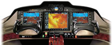
The configuration of the G1000 varies by aircraft manufacturer, and can include two 10- or 12- 15-inch LCDs. The Primary Flight Display (PFD) displays the standard heading, airspeed, altimeter, and navigation information, as well as a small map in the corner of the screen. The map displays up-to-the-minute information on aircraft location and can overlay air traffic and terrain information if enhanced situation awareness options are purchased.
Pilots can access a variety of screens through the Multi Function Display (MFD), including satellite weather, traffic awareness information, and checklists. In its standard mode, the MFD displays engine instrument information and a moving map. The two display screens are connected by a high-speed Ethernet data bus and each can display either the PFD or MFD, according to the pilot’s preference. Although a two-screen configuration is standard, larger business jets, such as the Citation Mustang, add a third 15-inch MFD LCD to the G1000 interface.
The two (or, in the case of Citation Mustang, three) LCDs offer pilots a unique level of situational awareness. The G1000 has built-in database of terrain, navigation, and airport information. Jeppesen offers subscription services which provide updated aviation database information monthly, and updated terrain/obstacle information bi-monthly. The built-in database can be updated easily through inserting SD memory cards into slots in the PFD or MFD.
A unique safety feature of the G1000 system is its SafeTaxi program. Pilots can access the database of more than 650 electronic US airport maps, complete with taxiway and runway names. Once the aircraft has landed, SafeTaxi superimposes the aircraft’s real-time position on the map so pilots can easily navigate confusing or unfamiliar airports.
Garmin offers a wide array of additional features that are either offered as standard or optional depending on the aircraft manufacturer. In addition to the Jeppesen terrain/traffic subscription services, FliteCharts may be added. This program is an electronic version of the NACO US Terminal Procedures, which include departure procedures and approach charts. An XM WX Satellite Weather subscription is available, which, when paired with a data link receiver, provides access to high-resolution weather throughout the US. A Class-B TAWS (Terrain Awareness and Warning System) is optional as well, which alerts the pilot when the aircraft flies in close proximity to terrain. A Garmin Mode S transponder may be added to display information about nearby aircraft. The color-coded terrain proximity alerts, minute-by-minute weather data, and air traffic information can be superimposed on Jeppesen maps for maximum real-time situational awareness.
In addition to superior situational awareness, Garmin’s G1000 avionics suite optimizes flight performance through its advanced GFC 700 autopilot, which can handle most tasks throughout flight. It can maintain a steady airspeed and automatically optimizes the aircraft’s performance during the climb and descent phases of flight. Perhaps most important of all, the GFC 700 has an emergency descent mode which is automatically activated in emergency situations ..
In summary, the G1000 provides the high-caliber performance expected in business aviation while exceeding all expectations in its situational awareness capabilities. Pilots flying with the G1000 have almost every advantage technology can offer. Superior quality meets superior efficiency in Garmin’s G1000 avionics suite.
